Drone Mapping
and we’ve placed more than 600 professionals
What is Drone Mapping?
Drone Mapping is a cutting-edge technique that utilizes unmanned aerial vehicles (UAVs) and drones to capture high-resolution aerial imagery and data. These drones are equipped with advanced sensors, such as cameras and LiDAR technology, which enable them to collect accurate and detailed information about the Earth’s surface.
By traversing an area of interest, the drones amass images and data points, which are then processed to produce highly accurate maps, 3D models, and other valuable outputs. Drone mapping delivers substantial efficiency, cost-effectiveness, and safety benefits, positioning it as an indispensable tool in contemporary surveying and mapping practices.
Drones have soared to new heights in today’s rapidly advancing technological landscape. Drone mapping has emerged as a game-changing tool, revolutionizing surveying and mapping processes across various industries.
At WorldTeams, we specialize in exceptional drone mapping services, offering unparalleled accuracy and efficiency. In this blog post, we will explore drone mapping and its diverse applications and highlight how our outsourcing services can unlock new perspectives and elevate precision for your projects.

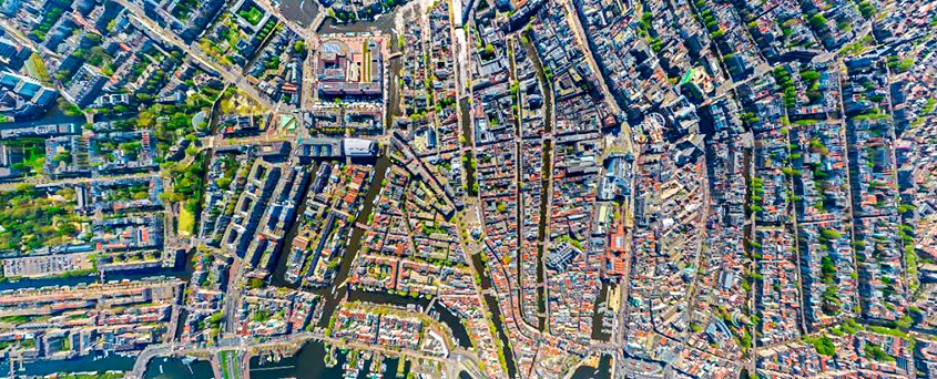
The Potential of Drone Mapping
Drone mapping services have gained significant traction due to their ability to capture high-resolution aerial imagery and generate precise topographical data. By employing advanced sensors and imaging technology, drones can efficiently collect data, providing accurate measurements and detailed 3D models of the surveyed areas. This technology offers many benefits, such as increased accuracy, reduced costs, enhanced safety, and faster turnaround times.
Looking to streamline your mapping workflows?

Applications of Drone Mapping
Construction and Infrastructure Development
Drone mapping plays a crucial role in the construction and infrastructure development sectors. Drones can swiftly capture comprehensive data on construction sites, monitor progress, and assist in project management. By generating accurate 3D models and orthomosaic maps, construction professionals can detect potential design flaws, streamline planning processes, and facilitate better decision-making.
Agriculture and Land Management
The agricultural industry has embraced drone mapping as a valuable crop monitoring and land management tool. Drones with various imaging sensors can capture multispectral and thermal data, providing invaluable insights into crop health, irrigation needs, and pest infestations. Farmers can make informed decisions regarding treatment plans, resource allocation, and yield optimization with this data.
Environmental Conservation and Natural Resource Management
Drone mapping is an indispensable asset in environmental conservation efforts. It enables the efficient monitoring and mapping of delicate ecosystems, forests, and wildlife habitats. By analyzing aerial data, researchers and environmental organizations can identify endangered areas, track deforestation, monitor wildlife populations, and develop effective conservation and sustainable resource management strategies.
LiDAR Drone Data Collection: Benefits and Advantages for Surveyors
At WorldTeams, we understand the significance of LiDAR drone data collection in revolutionizing surveying processes. LiDAR (light detection and ranging) technology allows for precise measurement of the Earth’s surface by detecting objects and their locations in real time. Equipping our drones with LiDAR and advanced instrumentation enables surveyors to gather accurate data quickly and efficiently.
The benefits of LiDAR drone data collection for surveyors are immense. LiDAR can penetrate through the tree canopy in large or heavily wooded areas, capturing data from the existing ground surface. This allows for creating a point cloud, which can be converted into contour files, 3D maps, and other deliverables. Compared to traditional methods, using LiDAR drones significantly speeds up the data collection process. For instance, in open areas without forest cover, our high-end LiDAR-equipped drones can cover up to 500-750 acres in just one day.
The advantages of drone data collection extend beyond speed. By combining traditional data collection methods with drone technology, surveyors can enhance the quality of their data while improving safety and reducing costs. Sending teams to dangerous terrains or remote locations can be risky and time-consuming.
However, with drone mapping services, areas with challenging terrain, icy conditions, or wildlife concerns can be safely surveyed without risking human lives. Additionally, drones can capture data quickly and automatically, reducing costs associated with manual surveys.


Outsourcing Drone Mapping Services
At WorldTeams, we pride ourselves on offering comprehensive drone mapping services tailored to our clients’ needs. Our experienced drone surveyors are proficient in utilizing cutting-edge aerial technology to deliver exceptional results. By outsourcing your drone mapping requirements to us, you can leverage our expertise, save time and resources, and focus on other critical aspects of your projects.
Supporting Diverse Sectors with Drone Mapping Services
Agriculture
Surveying is vital in precision agriculture, helping farmers optimize crop yields, assess soil quality, and monitor irrigation needs.
Construction
Surveying is crucial in all stages of the construction process, from land assessment and planning to site preparation and project completion.
Conservation and Environmental
Surveying supports environmental conservation efforts by mapping ecosystems, monitoring wildlife habitats, and assessing the impact of development on natural resources.
Mining
Accurate surveying ensures proper resource evaluation, mine planning, and monitoring of excavation activities in the mining industry.
Forestry Management
Surveying aids in forest inventory assessment, timber cruising, and monitoring forest health and growth for sustainable management practices.
Solar Farm Maintenance
Surveying assists in determining the optimal layout for solar panel installations, ensuring maximum sunlight exposure and efficient energy production.
Government Agencies
Government agencies use surveying for infrastructure development, land management, urban planning, and disaster management.
Land Development
Surveying helps in land subdivision, boundary demarcation, and the creation of accurate legal descriptions for land transactions
Transmission and Distribution Inspection
Surveying facilitates the inspection and monitoring of utility infrastructure, such as power lines, ensuring their structural integrity and efficiency.
With our nationwide network of licensed and insured drone pilots, WorldTeams is well-equipped to cater to the unique surveying needs of these industries. We have years of experience collaborating with surveyors and mappers to meet their project requirements.
Why choose WorldTeams for Drone Mapping Services?
Expertise and Experience
Our team comprises skilled professionals who possess extensive knowledge of drone surveying techniques and industry best practices. We are well-equipped to handle diverse projects and ensure accurate data collection and analysis.
State-of-the-Art Technology
We employ the latest drone technology and advanced imaging sensors to capture detailed and precise aerial data for mapping and surveying purposes. Our commitment to staying updated with technological advancements guarantees you access to cutting-edge services.
Timeliness and Efficiency
We understand the significance of timely project delivery. With our streamlined processes and efficient workflows, we ensure quick turnaround times without compromising on quality. Our team is dedicated to meeting your project deadlines and exceeding your expectations
In Conclusion
Drone mapping has emerged as a transformative tool, revolutionizing surveying and mapping processes across various industries. At WorldTeams, we offer exceptional outsourcing services in drone mapping, providing you with accurate and detailed data to unlock new perspectives for your projects. Embrace the power of aerial technology and elevate precision with our drone mapping services. Revolutionize your surveying and mapping workflows today!

